Month: November 2022

  • Land For Sale Near Me

    Land For Sale Near Me

    Whether you are looking for a building plot, a rural smallholding or a development opportunity, finding land for sale in the right location is the first step. However, once you find a plot, there is a legal process to navigate — and accurate Land Registry plans play a crucial part in making sure your purchase goes through smoothly.

    In this guide, we cover the best websites for searching for land for sale across the UK, explain what to check before buying, and set out the Land Registry plans you will need when your transaction reaches the conveyancing stage.

    Why we wrote this guide: Towers Richardson has prepared Land Registry plans for land purchases since 1994. We regularly work with buyers, solicitors and developers who need compliant title plans and transfer plans for land transactions. This guide brings together the search resources and the practical plan advice in one place.

    The best place to start looking for land for sale is online. There are several property portals and specialist websites that list land, building plots and development sites across England, Wales, Scotland and Northern Ireland.

    We have grouped the most useful search resources into categories below. Some focus on residential building plots, others specialise in rural land, woodland or commercial development opportunities. Using a combination of these sites gives you the broadest view of what is available in your target area.

    Main Property Portals

    The major property portals all include land listings alongside residential and commercial property. These are the best starting points for finding land for sale in any part of the UK.

    Website What It Covers
    Rightmove The UK’s largest property portal — search for land and building plots by location, price and size
    OnTheMarket A growing portal with a dedicated land section, including development sites
    Your Move National estate agency chain listing land and plots alongside residential property
    PropertyPal The leading property portal for Northern Ireland, including land and sites

    These portals aggregate listings from local and national estate agents, giving you a wide range of land for sale from a single search. You can filter results by location, price range, plot size and land type.

    Specialist Land Search Websites

    If you are specifically looking for building plots or development land, these specialist websites focus exclusively on land for sale rather than general property.

    Website What It Covers
    PlotFinder Specialist portal for self-build plots and building land across the UK
    AddLand Land marketplace with detailed mapping tools showing ownership boundaries, planning history and environmental data
    Woods4Sale Specialist in woodland and forest plots, with land for sale across England, Scotland and Wales
    Tustins Land and property auctioneers, often listing development sites and plots at auction

    Search tip: AddLand is particularly useful for due diligence. It overlays Land Registry title boundaries, planning application data and environmental information on a map, giving you a detailed picture of any plot before you even visit it.

    Rural Land, Farms and Woodland

    If you are looking for agricultural land, farmland, estates or woodland for sale, these specialist agents and portals focus on the rural property market.

    Website What It Covers
    UK Land and Farms Specialist portal for farms, rural estates and agricultural land
    Knight Frank Leading estate agent for country houses, farms and rural estates
    Strutt & Parker Rural property specialists with farm, estate and land listings across England, Scotland and Wales
    Fox & Sons Regional estate agent covering the South of England, with rural land and property listings
    Woodlands.co.uk Small woodland plots for sale across England, Scotland and Wales — ideal for conservation, recreation or investment
    Forests.co.uk Larger forest and woodland properties, including commercial forestry and estate plantations
    Savills Major national agent with a strong rural and estates division covering farms, development land and rural commercial property

    Rural land purchases often involve larger areas, complex boundaries and unregistered land — all of which can require specialist Land Registry plans to complete the transaction.

    Found Land for Sale? Need a Plan?

    We prepare compliant title plans and transfer plans for land purchases. 100% HMLR acceptance rate. Most plans delivered within 24–48 hours.

    Get a Free Quote

    Estate Agents and Land Agents

    Not all land for sale appears on the major online portals. Local estate agents and specialist land agents often have plots available that are not widely advertised — particularly smaller parcels, infill plots and off-market opportunities.

    If you are searching in a specific area, it is worth contacting local agents directly and asking to be added to their mailing list for land and plots. Many agents will notify you of new listings before they appear online, giving you an early opportunity to view and make an offer.

    For development land and larger sites, specialist land agents and commercial property firms such as Savills, Knight Frank and Strutt & Parker often handle sales that are marketed exclusively through their own networks.

    What to Check Before Buying Land

    Finding land for sale is the exciting part. However, before committing to a purchase, there are several important checks that you or your solicitor should carry out.

    • Title and ownership — is the land registered at HM Land Registry? Who owns it? Are there any charges, restrictions or covenants on the title?
    • Planning status — does the land have planning permission for your intended use? If not, what are the prospects of obtaining it?
    • Access — does the land have legal access from a public highway? If access is across third-party land, is there a formal right of way?
    • Boundaries — are the boundaries clear and agreed? Do they match what is shown on the title plan?
    • Services — is the land connected to mains water, electricity, gas and drainage? If not, what are the costs of connection?
    • Environmental considerations — is the land in a flood zone, conservation area, or subject to tree preservation orders or ecological designations?
    • Local authority searches — these reveal planned developments, road schemes and other matters that could affect the value or use of the land
    • Unregistered land — if the land is not registered at HMLR, additional investigations are needed to establish ownership and any existing rights over the land

    Your solicitor or conveyancer will carry out the detailed legal checks as part of the conveyancing process. However, understanding these issues early helps you avoid costly surprises later.

    Planning tip: Land with full planning permission is almost always more expensive than land without. However, buying land without planning permission carries the risk that consent may not be granted. If you are buying land for sale with the intention of building on it, check the planning status carefully before exchanging contracts.

    What Land Registry Plans Do You Need?

    When you buy land, the conveyancing process will require one or more Land Registry-compliant plans depending on the nature of the transaction. Here are the most common scenarios.

    Buying the Whole of a Registered Title

    If you are buying land that is already registered and you are purchasing the entire title, a new plan is not usually required. The existing title plan held by HMLR will remain in place, and ownership simply transfers to you.

    Buying Part of a Registered Title

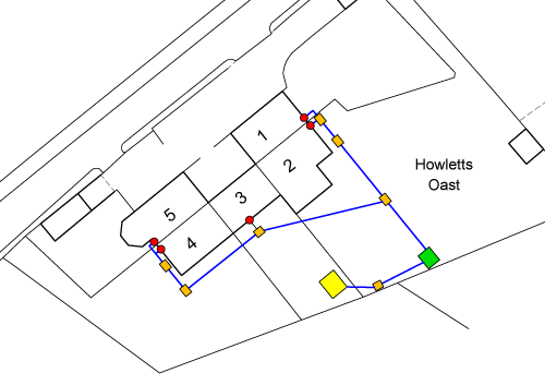
    If you are buying part of someone else’s land — for example, a building plot carved out of a larger title — a transfer plan is required. This accompanies the TP1 transfer deed and shows HMLR exactly which part of the title is being transferred to you and which part the seller is keeping.

    First Registration of Unregistered Land

    If the land you are buying is unregistered (it does not currently have a title number at HMLR), your solicitor will need to apply for first registration after completion. This requires a title plan showing the boundaries of the land you are registering.

    Land With Complex Boundaries or Multiple Parcels

    For larger purchases involving multiple fields, parcels or access routes, several plans may be needed — potentially at different scales — to clearly show all of the land being acquired and any rights being granted or reserved.

    In every case, the plan must comply with HM Land Registry’s requirements under Practice Guide 40. Plans that do not meet these standards will be rejected, causing delays to your transaction.

    Common Issues With Land Purchases

    Land transactions can be more complex than standard house purchases. After 30 years of preparing plans for land buyers and their solicitors, we regularly see the following issues arise:

    • Boundaries on the ground do not match the title plan — fences, hedges and walls may not align with the registered boundary, creating uncertainty about exactly what you are buying
    • The land is unregistered — with no HMLR title, establishing ownership requires a chain of deeds and may involve a Search of the Index Map to check for any existing registrations
    • Access is unclear — the land may not have a formal right of way, or the access route may cross land owned by a third party
    • Existing plans are non-compliant — estate agent sales particulars and marketing plans often carry prohibited phrases like “not to scale” and cannot be used for Land Registry purposes
    • Overlapping titles — in some cases, parts of the land may already be included in a neighbouring registered title, creating a conflict that needs resolving
    • Planning restrictions or covenants — restrictions on the title may limit what you can do with the land, even if it appears to have development potential

    Each of these issues requires careful handling — and in most cases, accurate Land Registry plans are part of the solution. Whether it is a fresh title plan for a first registration or a transfer plan to resolve a boundary issue, getting the plan right is essential for completing the transaction.

    How Towers Richardson Can Help

    At Towers Richardson, we prepare Land Registry-compliant plans for land purchases across England and Wales. Whether you are buying a small building plot, a large rural parcel or a multi-plot development site, we have the experience to deliver the plans your solicitor needs.

    Here is what we offer:

    • Title plans — for first registrations of unregistered land
    • Transfer plans — for purchases of part of a registered title (TP1 transfers)
    • 100% HMLR acceptance rate — every plan is checked against Practice Guide 40 before delivery
    • Licensed Ordnance Survey data — we work directly with current OS MasterMap data in our CAD systems
    • 30+ years of specialist experience — we have been preparing plans for land transactions since 1994
    • Fast turnaround — most plans delivered within 24 to 48 hours, with same-day options available
    • Nationwide coverage — we serve clients across England and Wales from our base in South Yorkshire
    • Fixed-price quotes — no hidden fees, with costs confirmed before any work starts

    Plans start from £115. Request a quote and we will respond within 1 hour during business hours.

    30+ Years. 100% Acceptance Rate.

    Trusted by solicitors, developers and property professionals across England and Wales since 1994.

    Request Your Free Quote

    Frequently Asked Questions

    Where can I find land for sale near me?

    The best starting points are the major property portals — Rightmove and OnTheMarket — which both have dedicated land sections. For specialist searches, PlotFinder focuses on self-build plots, AddLand offers detailed mapping and ownership data, and rural agents like Knight Frank and Strutt & Parker list farms, estates and woodland.

    Do I need a Land Registry plan when buying land?

    It depends on the transaction. If you are buying the whole of an already-registered title, a new plan is not usually needed. If you are buying part of a title or the land is unregistered, you will need a compliant plan — either a transfer plan or a title plan for first registration.

    What checks should I do before buying land?

    Key checks include confirming ownership and title status, planning permission, legal access, boundary accuracy, service connections, flood risk and any restrictions or covenants on the land. Your solicitor will carry out these checks as part of the conveyancing process.

    What is unregistered land?

    Unregistered land is land that does not currently have a title registered at HM Land Registry. When you buy unregistered land, your solicitor must apply for first registration, which requires a compliant title plan showing the boundaries of the land being registered.

    How much does a Land Registry plan cost for a land purchase?

    Plans start from £115 for standard title plans and transfer plans. More complex sites involving multiple parcels or large areas are priced on a project basis. We provide fixed-price quotes upfront — contact us for a personalised quote.

    Can I use the estate agent’s plan for Land Registry purposes?

    No. Estate agent plans are typically marked “for identification purposes only” or “not to scale,” which are prohibited phrases under HMLR’s requirements. A purpose-prepared Land Registry plan based on Ordnance Survey data is needed for registration.

    How long does a Land Registry plan take?

    We typically deliver plans within 24 to 48 hours. Same-day urgent turnarounds are available when needed.

    Buying Land? We Can Help With the Plans.

    Towers Richardson has been preparing Land Registry-compliant plans since 1994. Whether you have found land for sale and need a title plan for first registration or a transfer plan for a partial purchase, we prepare every plan to Practice Guide 40 standards and deliver with a 100% HMLR acceptance rate.

    We work with solicitors, buyers, developers and property professionals across England and Wales.

    Get in touch today:

    📧 info@towers-richardson.co.uk
    📞 01226 885040
    💬 WhatsApp: 07543 434048

    Or request a free quote online — we respond within 1 hour during business hours.

  • How to find my house plans

    How to find my house plans

    If you want to find your house plans, the quickest and easiest way is through your Local Planning Authority’s website. Most councils now have their planning records available online, meaning you can search for and download drawings of your property from home — completely free of charge.

    In this guide, we walk you through the process step by step with screenshots, explain where to look if your property was built before online records were available, and cover the difference between planning drawings and the Land Registry plans you may need for a property transaction.

    Important distinction: The house plans you can find through your local council are planning application drawings — floor plans, elevations and site plans submitted by the architect or builder when the property was built or altered. These are not the same as Land Registry plans (title plans), which show the legal boundaries of your property. If you need a Land Registry plan, contact us and we can help.

    Where to Find Your House Plans

    The best place to find your house plans is your Local Planning Authority (LPA). Every council in England and Wales keeps records of planning applications, and most now make these accessible through an online search portal.

    When a property is built, extended or altered, the builder or homeowner submits planning drawings to the council as part of the planning application. These drawings typically include floor plans, elevations, site plans and sometimes structural details. Once the application is determined, these documents remain on file as a public record.

    How Far Back Do Online Records Go?

    Most councils have digitised their planning records going back approximately 20 years. If your house was built or altered within this period, there is a good chance you can find the plans online. For older properties, you may need to contact the council directly or visit your local library — we cover this in more detail below.

    To find your Local Planning Authority, you can use the GOV.UK search tool: Find your local council on GOV.UK.

    Step-by-Step: How to Find My House Plans Online

    Every council’s website is slightly different, but the process for finding your house plans follows the same general pattern. Here is a step-by-step walkthrough.

    Step 1 Find Your Local Planning Authority Website

    Start by searching for your Local Planning Authority’s website. You can use the GOV.UK council finder to identify which council covers your area. Once you are on their website, look for a section called “Planning” or “Planning applications.”

    Step 2 Find the Online Planning Search

    On the council’s planning page, look for a link or button that says something like “View or comment on planning applications online,” “Search planning applications” or “Public Access.” This will take you to their online planning portal.

    Screenshot showing the view or comment on planning applications link on a council website

    Step 3 Access the Public Search Portal

    Many councils use a system called “Public Access” for their planning records. You may see a link labelled “View Public Access” or similar. Click through to reach the search screen.

    Screenshot showing the View Public Access link on a planning portal

    Step 4 Search for Your Property

    You should now see a simple search screen. Type in your address — the postcode usually works best — and click “Search.” The system will return a list of planning applications associated with your property.

    Screenshot showing the planning application search screen with address field

    Step 5 Find the Right Application

    The search results may show several planning applications for the same property — original construction, extensions, conversions and other alterations. Check the description and date of each one to find the application you are interested in. The listing will tell you how many documents are associated with each application.

    Screenshot showing planning application search results with multiple applications listed

    Step 6 View and Download the Plans

    Open the application and navigate to the “Documents” tab. You will see a list of all the documents submitted with the application. Drawings are typically indicated by an icon showing two rulers in an L-shape. Click the “View” link (usually shown as a document icon with a magnifying glass) to open the PDF of the drawing. From here you can view, download and print your house plans.

    Screenshot showing the documents tab with drawing files available to view and download

    Tip: If you cannot find your house plans using the online search, try different search terms — your house name, the street name without a number, or just the postcode. Some older records may be indexed differently from how you expect.

    What If My House Was Built Before Online Records?

    If your property was built more than 20 years ago, the planning records may not be available online. In that case, you have several options to find your house plans.

    • Contact your council directly — phone or email the planning department and ask for copies of the original planning application drawings. There may be a small fee for retrieving archived records
    • Visit your local library — many libraries hold copies of historical planning records and building control archives, particularly for significant local buildings
    • Check with the original builder or architect — if you know who designed or built the property, they may still hold copies of the original drawings
    • Ask previous owners — the seller or their solicitor may have retained copies of plans from when the property was purchased or altered
    • Building control records — your council’s building control department holds separate records from planning, and these sometimes include floor plans and structural drawings
    • Commission a measured survey — if no original plans exist, a surveyor can carry out a measured survey of the property and produce accurate floor plans from scratch

    Other Places to Find House Plans

    Beyond the Local Planning Authority, there are several other sources where you may be able to find drawings of your property.

    HM Land Registry Title Plans

    Every registered property in England and Wales has a title plan held by HM Land Registry. This is not a detailed house plan — it is a boundary plan showing the extent of your property on the Ordnance Survey map. You can order a copy of your title plan from the HM Land Registry website for a small fee.

    Your Mortgage Lender or Solicitor

    When you purchased your property, your solicitor will have obtained copies of the title documents — including the title plan. Your mortgage lender may also hold copies on file. It is worth contacting them if you need a copy of the boundary plan.

    The Deeds

    If your property is older and was purchased before compulsory registration, the original paper deeds may include plans. These deeds are sometimes held by your solicitor, your mortgage lender, or by you personally if the property is owned outright.

    Need a Land Registry Plan?

    Planning drawings are not the same as Land Registry plans. If you need a compliant title plan, lease plan or transfer plan, we can help.

    Get a Free Quote

    Planning Drawings vs Land Registry Plans

    This is an important distinction that many people overlook. The house plans you find through your Local Planning Authority are planning application drawings. They are not the same as Land Registry plans, and they serve different purposes.

    Feature Planning Drawings Land Registry Plans
    Purpose Show what is being built or altered Show the legal boundaries and extent of ownership
    Contents Floor plans, elevations, site layout, sections Boundary plan on OS base map
    Who produces them Architect or building designer Land Registry plan specialist or surveyor
    Used for Planning permission, building control Property registration, sales, transfers, leases
    Can it be used at Land Registry? No — usually carries prohibited phrases Yes — prepared to Practice Guide 40 standards

    Planning drawings often carry disclaimers such as “not to scale” or “for planning purposes only.” These phrases mean the plans cannot be submitted to HM Land Registry. If you need a plan for a property transaction — selling, transferring or leasing your home — you need a purpose-prepared Land Registry plan.

    When You Need a Land Registry Plan Instead

    While finding your house plans through the council is useful for understanding the layout and design of your property, there are situations where you need a different type of plan entirely. You will need a Land Registry-compliant plan when:

    • Selling part of your land or garden — a transfer plan is required to accompany the TP1 transfer deed
    • Granting a lease of 7 years or more — a lease plan with detailed floor plans is mandatory for HMLR registration
    • First registration of unregistered land — a title plan must accompany the application
    • Correcting or updating your title plan — where the existing boundary plan held by HMLR is inaccurate
    • Boundary disputes — an accurate plan based on OS data can help clarify the position

    In each of these cases, the plan must comply with HM Land Registry’s requirements under Practice Guide 40. Planning drawings from the council will not be accepted.

    How Towers Richardson Can Help

    At Towers Richardson, we specialise in Land Registry-compliant plans — the plans you need for property transactions, not the planning drawings held by your council. If you need a title plan, transfer plan or lease plan, we can prepare it to HMLR standards and deliver within 24 to 48 hours.

    Here is what we offer:

    • 100% HMLR acceptance rate — every plan is checked against Practice Guide 40 before delivery
    • Licensed Ordnance Survey data — we work directly with current OS MasterMap data
    • 30+ years of specialist experience — preparing Land Registry plans since 1994
    • Fast turnaround — most plans delivered within 24 to 48 hours, with same-day options available
    • Nationwide coverage — we serve clients across England and Wales
    • Fixed-price quotes from £115 — no hidden fees, costs confirmed before work starts

    30+ Years. 100% Acceptance Rate.

    Trusted by solicitors, developers and property professionals across England and Wales since 1994.

    Request Your Free Quote

    Frequently Asked Questions

    How can I find my house plans?

    The easiest way to find your house plans is through your Local Planning Authority’s website. Most councils have an online planning portal where you can search by address and view or download the drawings submitted with planning applications for your property.

    Are house plans available online for free?

    Yes. Planning application documents, including house plans, are public records and can be viewed and downloaded free of charge through most council planning portals. Records are typically available online for properties built or altered within the last 20 years.

    What if my house was built more than 20 years ago?

    For older properties, online records may not be available. You can contact your council’s planning department directly to request archived records, visit your local library, check with the original builder or architect, or ask your solicitor if they hold copies from a previous purchase.

    Can I use planning drawings for a Land Registry application?

    No. Planning drawings typically carry phrases like “not to scale” which are prohibited by HM Land Registry. For property registrations, sales, transfers and leases, you need a purpose-prepared Land Registry plan that complies with Practice Guide 40.

    What is the difference between house plans and a title plan?

    House plans (planning drawings) show the design and layout of a building — floor plans, elevations and site layout. A title plan is a Land Registry document that shows the legal boundaries and extent of your property on the Ordnance Survey map. They serve completely different purposes.

    How do I find my Local Planning Authority?

    You can find your Local Planning Authority using the GOV.UK council finder at gov.uk/find-local-council. Enter your postcode and it will tell you which council handles planning for your area.

    What if no plans exist for my property?

    If no planning drawings exist — for example, for very old properties that pre-date the planning system — you can commission a measured survey. A surveyor will visit the property, take measurements using laser equipment, and produce accurate floor plans and elevations from scratch.

    Need a Land Registry Plan for Your Property?

    If you need a Land Registry plan rather than planning drawings, Towers Richardson can help. We have been preparing compliant title plans, lease plans and transfer plans since 1994, and we maintain a 100% HMLR acceptance rate on every plan we produce.

    We work with homeowners, solicitors, developers and property professionals across England and Wales.

    Get in touch today:

    📧 info@towers-richardson.co.uk
    📞 01226 885040
    💬 WhatsApp: 07543 434048

    Or request a free quote online — we respond within 1 hour during business hours.

  • Land Registry Drainage Plans

    Land Registry Drainage Plans

    A drainage plan is a scaled drawing that shows the route of drainage systems through or across a property. When drainage infrastructure crosses property boundaries — which it very often does — an accurate plan is essential for documenting easements, establishing maintenance responsibilities, and supporting property transactions at HM Land Registry.

    In this guide, we explain what a drainage plan is, why you might need one, how it differs from other utility plans, what information it must include, and how we prepare them at Towers Richardson. We also cover the related plan types — sewer location plans, water pipe route plans and cable route plans — that are often needed alongside drainage plans.

    Why trust this guide? Towers Richardson has been preparing Land Registry-compliant drainage plans and utility route plans since 1994. Every plan we produce is drawn to HMLR standards and we maintain a 100% acceptance rate.

    What Is a Drainage Plan?

    A drainage plan is a detailed, scaled drawing that identifies the route of drainage and sewerage infrastructure in relation to one or more properties. It shows where drains run, where they cross property boundaries, where they connect to the wider sewerage network, and the positions of key features such as manholes, inspection chambers and outfall points.

    In the context of Land Registry work, a drainage plan is typically prepared to support a deed or transfer that grants or reserves drainage rights over neighbouring land. When a drain runs beneath a property that is being sold, transferred or leased, the plan provides the visual record of exactly where that drain is located and which properties are affected.

    These plans are sometimes referred to as drainage route plans, drainage easement plans or sewer route plans, depending on the specific purpose. Whatever the terminology, the principle is the same: the plan must accurately show the drainage route on an Ordnance Survey base map at a suitable scale, compliant with HM Land Registry requirements.

    When Do You Need a Drainage Plan?

    A drainage plan is required in several common property scenarios. If any of the following apply, your solicitor is likely to need an accurate drainage plan as part of the transaction.

    • Granting a drainage easement — when a property owner grants a right for a neighbouring property’s drainage to run through their land, the easement deed must be accompanied by a plan showing the exact route
    • Reserving drainage rights on a transfer — when selling part of your land, you may need to reserve the right for your drainage to continue running through the land being sold, which requires a plan showing the route
    • New build developments — developers often need drainage plans to show how each plot connects to the site drainage network and where shared drains cross plot boundaries
    • Adopting drainage infrastructure — when a water company agrees to adopt private drains (typically under a Section 104 agreement), plans showing the drainage layout are needed
    • Resolving drainage disputes — where neighbours disagree about drainage responsibilities or access for maintenance, an accurate plan helps establish the position
    • Property sales with shared drainage — if the property being sold has drainage that serves other properties, or relies on drainage running through neighbouring land, the solicitor will need a plan to document the arrangement
    • Lease plans with drainage references — some leases include drainage easements or refer to drainage infrastructure that must be shown on the plan

    Key point: A drainage plan is not the same as a standard title plan. A title plan shows the boundaries of your property. A drainage plan shows the route of drainage infrastructure in relation to those boundaries. You may need both — particularly on a transfer or lease where drainage rights are being granted or reserved.

    What Does a Drainage Plan Show?

    A well-prepared drainage plan should include all of the information needed to identify the drainage route clearly and accurately. The specific content depends on the purpose of the plan, but typically includes:

    • The drainage route — shown as a clearly marked line (usually in a distinct colour) indicating the path of the drain through or across the property
    • Property boundaries — the registered boundaries of all properties affected by the drainage route
    • Manholes and inspection chambers — marked at their correct positions along the route
    • Connection points — where the private drainage connects to the public sewer network
    • Easement corridor — if a drainage easement is being granted, the plan may show a defined strip (for example, 3 metres either side of the drain centre line) within which the easement applies
    • Ordnance Survey base data — the plan must be based on current OS mapping so that HMLR can relate it to the title plan
    • Scale and north point — a stated metric scale with a scale bar, and a north arrow for orientation
    • Key or legend — explaining the colours and symbols used on the plan

    The level of detail required depends on the legal document the plan supports. A simple drainage route plan for a transfer deed may only need to show the drain line and boundaries. A more detailed plan for a Section 104 adoption or a complex development may need to include pipe sizes, gradients and additional infrastructure.

    Drainage Plan Examples

    Below are examples of drainage plans we have prepared at Towers Richardson. Each one shows the drainage route clearly marked in relation to the property boundaries, drawn on an Ordnance Survey base at an appropriate scale.

    Every drainage plan we produce is prepared using licensed Ordnance Survey data and professional CAD software, ensuring it meets HM Land Registry standards under Practice Guide 40.

    Need a Drainage Plan?

    We prepare compliant drainage plans, sewer route plans and utility plans for Land Registry applications. 100% HMLR acceptance rate.

    Get a Free Quote

    Drainage Easements and Why They Matter

    A drainage easement is a legal right that allows drainage infrastructure belonging to one property to run through land owned by another. These easements are extremely common — in most residential areas, drains regularly cross neighbouring properties on their way to the public sewer.

    When a drainage easement is created — either as part of a property sale, a new development, or a standalone deed — the easement must be clearly documented. This includes both a written description in the deed and a drainage plan showing the route on a scaled drawing.

    What a Drainage Easement Typically Includes

    • The right to drain — the right for water and waste to flow through the drain across the neighbouring property
    • Access for maintenance — the right to enter the neighbouring property to inspect, repair or replace the drainage infrastructure
    • An easement corridor — a defined strip of land either side of the drain (commonly 1 to 3 metres each side) within which the easement rights apply
    • Restrictions on the servient land — typically, the landowner through whose property the drain runs cannot build over or obstruct the drain or the easement corridor

    Without an accurate drainage plan, the easement cannot be properly registered at HM Land Registry. If the plan is unclear or the drainage route is not shown precisely, HMLR may raise a requisition — delaying the registration and the underlying transaction.

    Drainage plans are the most commonly requested utility route plan, but they are not the only type. At Towers Richardson, we also prepare the following related plans, all to Land Registry standards.

    Plan Type What It Shows When It Is Needed
    Sewer location plan The route of public and private sewers across or near the property Property sales, build-over agreements, development applications
    Water pipe route plan The route of water supply pipes through or across the property Easement deeds for water supply, development infrastructure
    Cable route plan The route of electricity cables, telecoms or fibre running through the property Wayleave agreements, utility easements, development sites
    Gas pipe route plan The route of gas mains or service pipes across the property Easement deeds, development infrastructure, HSE compliance

    In many transactions — particularly new developments — multiple utility route plans are needed alongside the standard title or transfer plan. We can prepare all of these as a coordinated set, ensuring consistency across every drawing.

    How We Prepare a Drainage Plan

    At Towers Richardson, we follow a clear process to ensure every drainage plan is accurate and compliant.

    1. Understanding the Requirement

    We start by discussing the requirement with you or your solicitor. This includes understanding the purpose of the plan (easement, transfer, lease or other), identifying which properties are affected, and confirming what drainage information is available.

    2. Gathering Drainage Data

    The drainage route information typically comes from one or more of the following sources: existing drainage surveys or CCTV reports, water company sewer records, site plans from the developer or builder, or information provided by the property owner or their solicitor. In some cases, a drainage survey may need to be carried out on site before the plan can be prepared.

    3. Preparing the Plan

    We plot the drainage route onto current licensed Ordnance Survey mapping using professional CAD software. The drain line, manholes, connection points and any easement corridor are clearly marked. The plan is drawn to an appropriate scale with a north point, scale bar and legend.

    4. Checking and Delivery

    Every drainage plan is reviewed against Practice Guide 40 requirements before delivery. We supply the plan as a high-resolution PDF, ready for attachment to the deed or application. Most plans are delivered within 24 to 48 hours.

    Common Issues With Drainage Plans

    After decades of preparing drainage plans, we regularly encounter the following issues — understanding them in advance helps avoid delays.

    • The drainage route is unknown — the property owner or solicitor does not know exactly where the drain runs, making a drainage survey necessary before the plan can be prepared
    • Water company records are inaccurate — sewer record plans from water companies are indicative only and may not reflect the actual position of the drainage on the ground
    • The drain route is not shown precisely enough — vague descriptions like “the drain running under the garden” are not sufficient for HMLR; the route must be plotted to a specific position on the plan
    • The plan does not match the deed description — if the easement deed describes the drain as running “from manhole A to manhole B” but the plan shows a different route, HMLR will raise a requisition
    • The easement corridor is not defined — some deeds grant an easement over a strip of land either side of the drain, and if this corridor is not clearly shown on the plan, it cannot be properly registered
    • Shared drainage is not properly documented — on older properties, shared drainage arrangements often exist informally with no easement in place, which becomes a problem when the property is sold

    How Much Does a Drainage Plan Cost?

    The cost of a drainage plan depends on the complexity of the drainage route and the number of properties involved. As a general guide, a straightforward drainage plan starts from £115.

    More complex plans — for example, those involving multiple drainage routes across several properties, development sites with extensive infrastructure, or plans that require coordination with water company records — are priced on a project basis. We always confirm the cost upfront before any work begins.

    We provide fixed-price quotes with no hidden fees. Request a quote and we will respond within 1 hour during business hours.

    How Towers Richardson Can Help

    At Towers Richardson, we prepare drainage plans and utility route plans every week for solicitors, developers and property professionals across England and Wales. Whether you need a single drainage plan for an easement deed or a full set of utility plans for a development site, we have the experience to deliver.

    • 100% HMLR acceptance rate — every drainage plan is checked against Practice Guide 40 before delivery
    • Licensed Ordnance Survey data — we work directly with current OS MasterMap data in our CAD systems
    • 30+ years of specialist experience — preparing drainage plans and utility route plans since 1994
    • Drainage, sewer, water pipe, cable and gas route plans — all plan types prepared to the same HMLR-compliant standard
    • Fast turnaround — most plans delivered within 24 to 48 hours, with same-day options available
    • Nationwide coverage — we serve clients across England and Wales from our base in South Yorkshire
    • Fixed-price quotes from £115 — no hidden fees, costs confirmed before work starts

    30+ Years. 100% Acceptance Rate.

    Trusted by solicitors, developers and property professionals across England and Wales since 1994.

    Request Your Free Quote

    Frequently Asked Questions

    What is a drainage plan?

    A drainage plan is a scaled drawing that shows the route of drainage infrastructure in relation to one or more properties. It identifies where drains run, where they cross property boundaries, and the positions of manholes and connection points. These plans are used to support easement deeds, property transfers and development applications at HM Land Registry.

    When do I need a drainage plan?

    You typically need a drainage plan when granting or reserving a drainage easement, selling or transferring property where drains cross boundaries, developing a site with shared drainage infrastructure, or resolving a drainage dispute. Your solicitor will advise whether a plan is required for your specific transaction.

    Is a drainage plan the same as a title plan?

    No. A title plan shows the legal boundaries of your property. A drainage plan shows the route of drainage infrastructure in relation to those boundaries. You may need both — for example, when transferring part of a title and granting a drainage easement at the same time.

    How much does a drainage plan cost?

    Drainage plans start from £115 for straightforward routes. More complex plans involving multiple properties or extensive infrastructure are priced on a project basis. We provide fixed-price quotes upfront — contact us for a personalised quote.

    How long does a drainage plan take?

    We typically deliver drainage plans within 24 to 48 hours of receiving your instructions and the necessary drainage route information. Same-day urgent turnarounds are available when needed.

    What information do you need to prepare a drainage plan?

    We need the property address or title number, details of the drainage route (from a drainage survey, water company records or site plans), and confirmation of the purpose of the plan (easement, transfer, lease or other). If you are unsure about any of this, we can discuss it with you or your solicitor.

    Can you prepare other utility route plans?

    Yes. In addition to drainage plans, we prepare sewer location plans, water pipe route plans, cable route plans and gas pipe route plans — all to HM Land Registry standards.

    What is a drainage easement?

    A drainage easement is a legal right that allows drainage infrastructure belonging to one property to run through land owned by another. It typically includes the right to drain, the right to access for maintenance, and a defined corridor either side of the drain. The easement is documented in a deed and registered at HMLR with an accompanying drainage plan.

    Need a Drainage Plan or Utility Route Plan?

    Towers Richardson has been preparing Land Registry-compliant drainage plans since 1994. Whether you need a drainage plan for an easement deed, a sewer route plan for a development, or a full set of utility plans for a complex site, we can help you get it right first time.

    We work with solicitors, developers, property professionals and homeowners across England and Wales.

    Get in touch today:

    📧 info@towers-richardson.co.uk
    📞 01226 885040
    💬 WhatsApp: 07543 434048

    Or request a free quote online — we respond within 1 hour during business hours.