A drainage plan is a scaled drawing that shows the route of drainage systems through or across a property. When drainage infrastructure crosses property boundaries — which it very often does — an accurate plan is essential for documenting easements, establishing maintenance responsibilities, and supporting property transactions at HM Land Registry.
In this guide, we explain what a drainage plan is, why you might need one, how it differs from other utility plans, what information it must include, and how we prepare them at Towers Richardson. We also cover the related plan types — sewer location plans, water pipe route plans and cable route plans — that are often needed alongside drainage plans.
Why trust this guide? Towers Richardson has been preparing Land Registry-compliant drainage plans and utility route plans since 1994. Every plan we produce is drawn to HMLR standards and we maintain a 100% acceptance rate.
What Is a Drainage Plan?
A drainage plan is a detailed, scaled drawing that identifies the route of drainage and sewerage infrastructure in relation to one or more properties. It shows where drains run, where they cross property boundaries, where they connect to the wider sewerage network, and the positions of key features such as manholes, inspection chambers and outfall points.
In the context of Land Registry work, a drainage plan is typically prepared to support a deed or transfer that grants or reserves drainage rights over neighbouring land. When a drain runs beneath a property that is being sold, transferred or leased, the plan provides the visual record of exactly where that drain is located and which properties are affected.
These plans are sometimes referred to as drainage route plans, drainage easement plans or sewer route plans, depending on the specific purpose. Whatever the terminology, the principle is the same: the plan must accurately show the drainage route on an Ordnance Survey base map at a suitable scale, compliant with HM Land Registry requirements.
When Do You Need a Drainage Plan?
A drainage plan is required in several common property scenarios. If any of the following apply, your solicitor is likely to need an accurate drainage plan as part of the transaction.
- Granting a drainage easement — when a property owner grants a right for a neighbouring property’s drainage to run through their land, the easement deed must be accompanied by a plan showing the exact route
- Reserving drainage rights on a transfer — when selling part of your land, you may need to reserve the right for your drainage to continue running through the land being sold, which requires a plan showing the route
- New build developments — developers often need drainage plans to show how each plot connects to the site drainage network and where shared drains cross plot boundaries
- Adopting drainage infrastructure — when a water company agrees to adopt private drains (typically under a Section 104 agreement), plans showing the drainage layout are needed
- Resolving drainage disputes — where neighbours disagree about drainage responsibilities or access for maintenance, an accurate plan helps establish the position
- Property sales with shared drainage — if the property being sold has drainage that serves other properties, or relies on drainage running through neighbouring land, the solicitor will need a plan to document the arrangement
- Lease plans with drainage references — some leases include drainage easements or refer to drainage infrastructure that must be shown on the plan
Key point: A drainage plan is not the same as a standard title plan. A title plan shows the boundaries of your property. A drainage plan shows the route of drainage infrastructure in relation to those boundaries. You may need both — particularly on a transfer or lease where drainage rights are being granted or reserved.
What Does a Drainage Plan Show?
A well-prepared drainage plan should include all of the information needed to identify the drainage route clearly and accurately. The specific content depends on the purpose of the plan, but typically includes:
- The drainage route — shown as a clearly marked line (usually in a distinct colour) indicating the path of the drain through or across the property
- Property boundaries — the registered boundaries of all properties affected by the drainage route
- Manholes and inspection chambers — marked at their correct positions along the route
- Connection points — where the private drainage connects to the public sewer network
- Easement corridor — if a drainage easement is being granted, the plan may show a defined strip (for example, 3 metres either side of the drain centre line) within which the easement applies
- Ordnance Survey base data — the plan must be based on current OS mapping so that HMLR can relate it to the title plan
- Scale and north point — a stated metric scale with a scale bar, and a north arrow for orientation
- Key or legend — explaining the colours and symbols used on the plan
The level of detail required depends on the legal document the plan supports. A simple drainage route plan for a transfer deed may only need to show the drain line and boundaries. A more detailed plan for a Section 104 adoption or a complex development may need to include pipe sizes, gradients and additional infrastructure.
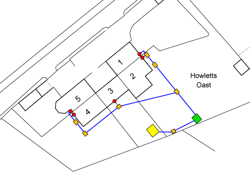
Drainage Plan Examples
Below are examples of drainage plans we have prepared at Towers Richardson. Each one shows the drainage route clearly marked in relation to the property boundaries, drawn on an Ordnance Survey base at an appropriate scale.


Every drainage plan we produce is prepared using licensed Ordnance Survey data and professional CAD software, ensuring it meets HM Land Registry standards under Practice Guide 40.
Need a Drainage Plan?
We prepare compliant drainage plans, sewer route plans and utility plans for Land Registry applications. 100% HMLR acceptance rate.
Get a Free QuoteDrainage Easements and Why They Matter
A drainage easement is a legal right that allows drainage infrastructure belonging to one property to run through land owned by another. These easements are extremely common — in most residential areas, drains regularly cross neighbouring properties on their way to the public sewer.
When a drainage easement is created — either as part of a property sale, a new development, or a standalone deed — the easement must be clearly documented. This includes both a written description in the deed and a drainage plan showing the route on a scaled drawing.
What a Drainage Easement Typically Includes
- The right to drain — the right for water and waste to flow through the drain across the neighbouring property
- Access for maintenance — the right to enter the neighbouring property to inspect, repair or replace the drainage infrastructure
- An easement corridor — a defined strip of land either side of the drain (commonly 1 to 3 metres each side) within which the easement rights apply
- Restrictions on the servient land — typically, the landowner through whose property the drain runs cannot build over or obstruct the drain or the easement corridor
Without an accurate drainage plan, the easement cannot be properly registered at HM Land Registry. If the plan is unclear or the drainage route is not shown precisely, HMLR may raise a requisition — delaying the registration and the underlying transaction.
Related Utility Route Plans
Drainage plans are the most commonly requested utility route plan, but they are not the only type. At Towers Richardson, we also prepare the following related plans, all to Land Registry standards.
| Plan Type | What It Shows | When It Is Needed |
|---|---|---|
| Sewer location plan | The route of public and private sewers across or near the property | Property sales, build-over agreements, development applications |
| Water pipe route plan | The route of water supply pipes through or across the property | Easement deeds for water supply, development infrastructure |
| Cable route plan | The route of electricity cables, telecoms or fibre running through the property | Wayleave agreements, utility easements, development sites |
| Gas pipe route plan | The route of gas mains or service pipes across the property | Easement deeds, development infrastructure, HSE compliance |
In many transactions — particularly new developments — multiple utility route plans are needed alongside the standard title or transfer plan. We can prepare all of these as a coordinated set, ensuring consistency across every drawing.
How We Prepare a Drainage Plan
At Towers Richardson, we follow a clear process to ensure every drainage plan is accurate and compliant.
1. Understanding the Requirement
We start by discussing the requirement with you or your solicitor. This includes understanding the purpose of the plan (easement, transfer, lease or other), identifying which properties are affected, and confirming what drainage information is available.
2. Gathering Drainage Data
The drainage route information typically comes from one or more of the following sources: existing drainage surveys or CCTV reports, water company sewer records, site plans from the developer or builder, or information provided by the property owner or their solicitor. In some cases, a drainage survey may need to be carried out on site before the plan can be prepared.
3. Preparing the Plan
We plot the drainage route onto current licensed Ordnance Survey mapping using professional CAD software. The drain line, manholes, connection points and any easement corridor are clearly marked. The plan is drawn to an appropriate scale with a north point, scale bar and legend.
4. Checking and Delivery
Every drainage plan is reviewed against Practice Guide 40 requirements before delivery. We supply the plan as a high-resolution PDF, ready for attachment to the deed or application. Most plans are delivered within 24 to 48 hours.
Common Issues With Drainage Plans
After decades of preparing drainage plans, we regularly encounter the following issues — understanding them in advance helps avoid delays.
- The drainage route is unknown — the property owner or solicitor does not know exactly where the drain runs, making a drainage survey necessary before the plan can be prepared
- Water company records are inaccurate — sewer record plans from water companies are indicative only and may not reflect the actual position of the drainage on the ground
- The drain route is not shown precisely enough — vague descriptions like “the drain running under the garden” are not sufficient for HMLR; the route must be plotted to a specific position on the plan
- The plan does not match the deed description — if the easement deed describes the drain as running “from manhole A to manhole B” but the plan shows a different route, HMLR will raise a requisition
- The easement corridor is not defined — some deeds grant an easement over a strip of land either side of the drain, and if this corridor is not clearly shown on the plan, it cannot be properly registered
- Shared drainage is not properly documented — on older properties, shared drainage arrangements often exist informally with no easement in place, which becomes a problem when the property is sold
How Much Does a Drainage Plan Cost?
The cost of a drainage plan depends on the complexity of the drainage route and the number of properties involved. As a general guide, a straightforward drainage plan starts from £115.
More complex plans — for example, those involving multiple drainage routes across several properties, development sites with extensive infrastructure, or plans that require coordination with water company records — are priced on a project basis. We always confirm the cost upfront before any work begins.
We provide fixed-price quotes with no hidden fees. Request a quote and we will respond within 1 hour during business hours.
How Towers Richardson Can Help
At Towers Richardson, we prepare drainage plans and utility route plans every week for solicitors, developers and property professionals across England and Wales. Whether you need a single drainage plan for an easement deed or a full set of utility plans for a development site, we have the experience to deliver.
- 100% HMLR acceptance rate — every drainage plan is checked against Practice Guide 40 before delivery
- Licensed Ordnance Survey data — we work directly with current OS MasterMap data in our CAD systems
- 30+ years of specialist experience — preparing drainage plans and utility route plans since 1994
- Drainage, sewer, water pipe, cable and gas route plans — all plan types prepared to the same HMLR-compliant standard
- Fast turnaround — most plans delivered within 24 to 48 hours, with same-day options available
- Nationwide coverage — we serve clients across England and Wales from our base in South Yorkshire
- Fixed-price quotes from £115 — no hidden fees, costs confirmed before work starts
30+ Years. 100% Acceptance Rate.
Trusted by solicitors, developers and property professionals across England and Wales since 1994.
Request Your Free QuoteFrequently Asked Questions
What is a drainage plan?
A drainage plan is a scaled drawing that shows the route of drainage infrastructure in relation to one or more properties. It identifies where drains run, where they cross property boundaries, and the positions of manholes and connection points. These plans are used to support easement deeds, property transfers and development applications at HM Land Registry.
When do I need a drainage plan?
You typically need a drainage plan when granting or reserving a drainage easement, selling or transferring property where drains cross boundaries, developing a site with shared drainage infrastructure, or resolving a drainage dispute. Your solicitor will advise whether a plan is required for your specific transaction.
Is a drainage plan the same as a title plan?
No. A title plan shows the legal boundaries of your property. A drainage plan shows the route of drainage infrastructure in relation to those boundaries. You may need both — for example, when transferring part of a title and granting a drainage easement at the same time.
How much does a drainage plan cost?
Drainage plans start from £115 for straightforward routes. More complex plans involving multiple properties or extensive infrastructure are priced on a project basis. We provide fixed-price quotes upfront — contact us for a personalised quote.
How long does a drainage plan take?
We typically deliver drainage plans within 24 to 48 hours of receiving your instructions and the necessary drainage route information. Same-day urgent turnarounds are available when needed.
What information do you need to prepare a drainage plan?
We need the property address or title number, details of the drainage route (from a drainage survey, water company records or site plans), and confirmation of the purpose of the plan (easement, transfer, lease or other). If you are unsure about any of this, we can discuss it with you or your solicitor.
Can you prepare other utility route plans?
Yes. In addition to drainage plans, we prepare sewer location plans, water pipe route plans, cable route plans and gas pipe route plans — all to HM Land Registry standards.
What is a drainage easement?
A drainage easement is a legal right that allows drainage infrastructure belonging to one property to run through land owned by another. It typically includes the right to drain, the right to access for maintenance, and a defined corridor either side of the drain. The easement is documented in a deed and registered at HMLR with an accompanying drainage plan.
Need a Drainage Plan or Utility Route Plan?
Towers Richardson has been preparing Land Registry-compliant drainage plans since 1994. Whether you need a drainage plan for an easement deed, a sewer route plan for a development, or a full set of utility plans for a complex site, we can help you get it right first time.
We work with solicitors, developers, property professionals and homeowners across England and Wales.
Get in touch today:
📧 info@towers-richardson.co.uk
📞 01226 885040
💬 WhatsApp: 07543 434048
Or request a free quote online — we respond within 1 hour during business hours.