A Land Registry compliant plan is one that meets all of HM Land Registry’s requirements for registration. If a plan does not comply, HMLR will reject the application — raising a requisition that delays the transaction and often requires the plan to be prepared again from scratch.
In this guide, we set out exactly what makes a plan Land Registry compliant, covering the core requirements that apply to all plans, the additional rules for lease plans and complex properties, the common mistakes that lead to rejections, and how you can ensure your plan passes first time. Everything is based on Practice Guide 40 — the official HMLR guidance that governs plan preparation.
Our track record: Every plan Towers Richardson produces is checked against Practice Guide 40 before delivery. We have maintained a 100% HMLR acceptance rate since 1994 — across thousands of title plans, transfer plans, lease plans and developer plans.
What Is a Land Registry Compliant Plan?
A Land Registry compliant plan is a drawing that meets all of the technical and content requirements set by HM Land Registry for property registration. When a plan is compliant, HMLR can use it to identify the land or property being registered, transferred or leased — and the application can proceed without delay.
Compliance is not optional. HMLR will raise a requisition — a formal request for corrections — if a plan fails to meet the required standards. This pauses the application until a corrected or replacement plan is submitted, adding weeks to the transaction and generating additional costs for all parties involved.
The requirements for a Land Registry compliant plan are set out in Practice Guide 40 (and its supplements), which is published by HMLR and updated periodically. Whether you are preparing a title plan for first registration, a transfer plan for a sale of part, or a lease plan for a new lease, the same fundamental standards apply.
Practice Guide 40 — The Standard
Practice Guide 40 is the definitive reference for preparing a Land Registry compliant plan. It is published by HMLR and covers the standards, specifications and requirements that every plan must meet.
The main guide covers the general requirements that apply to all plan types. Supplement 2 provides additional guidance specifically for lease plans, including the requirements for showing demised premises, floor levels and internal layouts.
The key areas covered by Practice Guide 40 include:
- Plan basis — what the plan must be based on (Ordnance Survey mapping)
- Scale — the appropriate scales for different property types
- Orientation — the requirement for a north point
- Content — what must be shown on the plan
- Colouring and marking — how boundaries and areas should be edged, coloured or hatched
- Prohibited content — phrases and features that must not appear on the plan
- Lease plan specifics — additional requirements for plans accompanying leases
You can read the full guide on GOV.UK: Practice Guide 40 and Supplement 2 (Lease Plans).
Core Requirements for All Plans
Every Land Registry compliant plan — regardless of type — must meet the following core requirements.
Based on the Ordnance Survey Map
The plan must be based on current Ordnance Survey mapping and show sufficient OS detail for HMLR to identify the land on the national map. This means surrounding roads, buildings and other features must be visible to provide context. Plans that are not based on OS data — for example, hand-drawn sketches, architect’s drawings or estate agent site plans — will not be accepted.
Drawn to a Stated Metric Scale
The plan must be drawn to a specific metric scale, and that scale must be clearly stated on the plan. The scale must be accurate — if the plan states 1:1250 but the drawing has been resized, HMLR will identify the discrepancy. A scale bar should also be included to allow verification.
Showing Orientation
A north arrow must appear on the plan to confirm its orientation. This is a basic requirement but one that is occasionally overlooked on hastily prepared plans.
Showing Sufficient Detail
The plan must show the whole of the property being registered, transferred or leased, including any associated land such as garden ground, garages, parking spaces, bin stores and access routes. Buildings must be shown in their correct or intended position.
Clear Boundary Marking
The land or property must be clearly identified on the plan. This is typically done by edging the boundary in a continuous colour (usually red for the land being registered or transferred) that forms a complete enclosure with no gaps. Where different areas need to be distinguished — for example, transferred and retained land on a transfer plan — different colours must be used.
Scale Requirements
The scale of a Land Registry compliant plan must be appropriate to the property type and size. Practice Guide 40 specifies the following.
| Property Type | Recommended Scale |
|---|---|
| Individual flats, apartments and small units | 1:200 or 1:500 |
| Urban residential properties | 1:1250 |
| Larger urban sites and developments | 1:1250 or 1:2500 |
| Rural properties and farmland | 1:2500 |
| Very large rural areas | 1:10000 or smaller |
Lease plans for individual flats or units within a building are typically prepared at 1:200 or 1:500 to show the internal layout at a readable size. Title plans and transfer plans for standard residential properties are most commonly prepared at 1:1250 in urban areas and 1:2500 in rural areas.
The scale must be accurate when printed. If a plan is printed at a different size from the original — for example, if an A3 plan is printed on A4 paper — the scale will be wrong and the plan will not be compliant.
Need a Compliant Plan?
Every plan we produce is checked against Practice Guide 40 before delivery. 100% HMLR acceptance rate since 1994.
Get a Free QuoteColouring and Marking
A Land Registry compliant plan must use colour and marking to clearly identify the land or property. The conventions vary depending on the plan type, but the general principles are consistent.
Title Plans and First Registration
The boundary of the property is edged in red, forming a complete enclosure. The edging must be clearly visible and must not obscure the detail beneath it.
Transfer Plans (TP1/TP2)
The land being transferred is edged in red. The retained land is edged in blue. Any rights of way or easements are shown in a different colour — typically brown for access routes and green for communal areas.
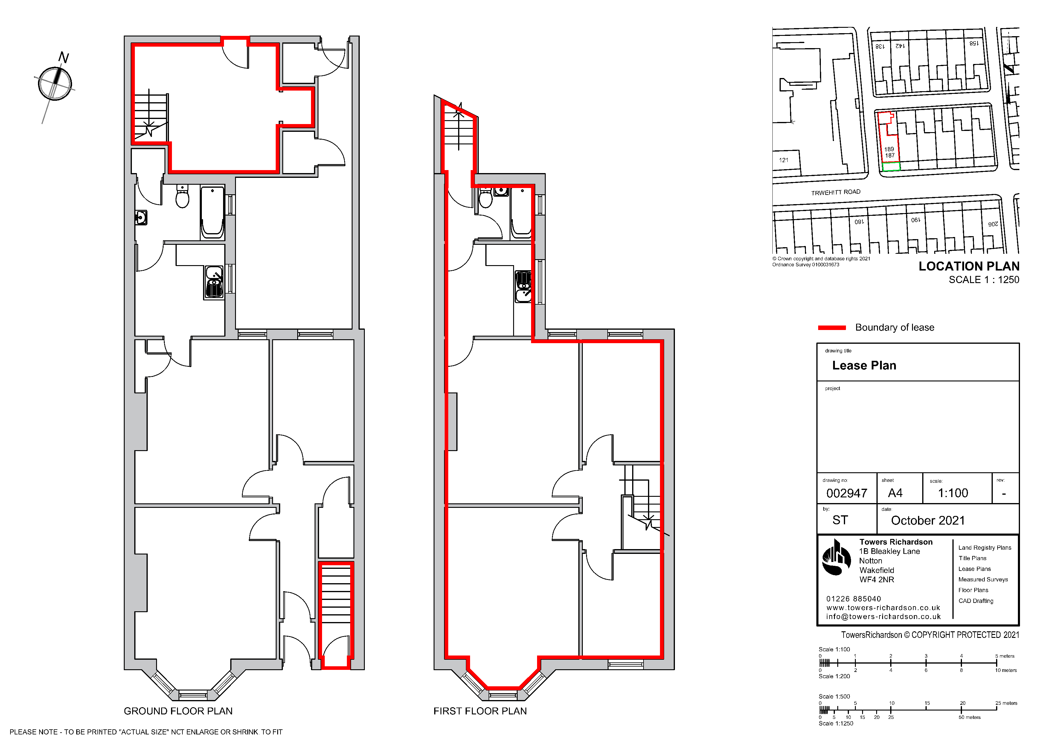
Lease Plans
The demised premises (the area being leased) are typically edged in red or shown with a coloured wash. Communal areas are shown in a different colour, and any rights over other parts of the building (such as access routes or shared facilities) are identified using additional colours or hatching.
In all cases, the colours must be clearly distinguishable from each other and from the base OS detail when printed. Colours that merge or become ambiguous on paper will result in a requisition from HMLR.
Additional Requirements for Lease Plans
Lease plans have additional requirements beyond the core standards. These are set out in Practice Guide 40 Supplement 2 and reflect the fact that leases often cover complex three-dimensional spaces within buildings rather than simple parcels of land.
A Land Registry compliant plan for a lease must meet all of the core requirements and the following additional standards.
- Relationship to the building footprint — the plan must show where the demised premises sit in relation to the external footprint of the building and the surrounding detail on the Ordnance Survey map
- Floor-level plans — if the lease covers property on more than one floor, or if the extent of the demise varies by floor, separate plans must be provided for each level
- Subsoil and airspace — if the lease includes land below or above ground level (for example, a basement or an upper-floor flat), the plan must show the relevant levels, ideally referenced to Ordnance Survey Datum
- Intricate boundaries — internal divisions within a building, such as party walls between flats, must be shown clearly so that the exact extent of the demise can be identified
- Communal areas — shared spaces such as hallways, stairwells, lifts and bin stores must be shown and distinguished from the demised premises
- Access routes — the routes by which the tenant accesses the demised premises from the building entrance should be identifiable on the plan
Why lease plans are more complex: A title plan shows a boundary on the ground. A lease plan must show a three-dimensional space within a building — including which floors, walls, ceilings and shared areas are included. This is why lease plans require detailed floor plans at larger scales (1:200 or 1:500) in addition to the location plan showing the building on the OS map.
Prohibited Phrases and Common Errors
Certain phrases and features will cause a plan to fail compliance, regardless of how well it is drawn. These are the most common errors that result in HMLR rejections.
Prohibited Phrases
The following phrases must never appear on a Land Registry compliant plan:
- “Not to scale” — if the plan is not to scale, it cannot be used for Land Registry purposes
- “For identification purposes only” — this implies the plan is approximate, which undermines its value for registration
- “For illustrative purposes only” — same principle as above
- “Do not scale from this drawing” — contradicts the requirement for a stated, accurate scale
- “Subject to survey” — suggests the plan may change, which is not acceptable for a definitive registration document
- “Approximate boundary” — all boundaries on a registration plan must be shown as definitively as the OS data allows
Other Common Errors
- Boundary edging with gaps — the red (or other) edging must form a complete enclosure with no breaks
- No north arrow — a basic omission that still causes rejections
- Missing scale bar — the scale must be stated and verifiable
- Insufficient surrounding detail — the plan must show enough context (roads, buildings, features) for HMLR to locate it on the OS map
- Inconsistency with the deed — the plan must match the verbal description in the transfer, lease or other document it accompanies
- Plan not based on OS data — architect’s drawings, estate agent plans and builder’s site plans are not acceptable without an OS base
- Scale distorted by printing — if an A3 plan is printed at A4 size, the scale changes and the plan is no longer compliant
Requirements by Plan Type
While the core requirements are the same, each plan type has specific considerations that affect compliance.
| Plan Type | Key Compliance Points |
|---|---|
| Title plan | Property edged red on OS base, full extent of ownership shown, sufficient surrounding detail, no prohibited phrases |
| Transfer plan | Transferred land edged red, retained land edged blue, rights of way shown in separate colour, matches TP1/TP2 deed description |
| Lease plan | Floor plans at 1:200 or 1:500, location plan on OS base, demised area clearly marked, communal areas shown, PG40 Supplement 2 compliance |
| Developer plan | Individual plot boundaries clearly defined, consistent numbering, rights and infrastructure shown, works across full site layout |
Compliance Checklist
Before submitting any plan to HM Land Registry, check it against this compliance checklist. Every item must be satisfied for the plan to be accepted.
- Based on current Ordnance Survey mapping — licensed OS data, not a sketch or architect’s drawing
- Drawn to a stated metric scale — clearly printed on the plan with a scale bar
- Scale is accurate when printed — check by measuring the scale bar with a ruler
- North arrow present — confirming the orientation of the plan
- Sufficient surrounding detail — roads, buildings and features visible for context
- The whole property is shown — including gardens, garages, parking, access routes
- Buildings in correct position — matching the OS mapping or shown in intended position for new builds
- Boundaries form a complete enclosure — no gaps in the red (or other colour) edging
- Colours are clear and distinguishable — will remain readable when printed
- No prohibited phrases appear — no “not to scale,” “for identification only” or similar
- Plan matches the deed description — the visual and verbal descriptions are consistent
- Lease plan specifics met — floor plans, building footprint relationship, communal areas (if applicable)
- Date of preparation included — a record of when the plan was produced
Our process: At Towers Richardson, every plan goes through a compliance check against this list before it leaves our office. It is this systematic approach that has allowed us to maintain a 100% HMLR acceptance rate across thousands of plans since 1994.
How Towers Richardson Can Help
Preparing a Land Registry compliant plan requires specialist knowledge of Practice Guide 40, access to licensed Ordnance Survey data, and professional CAD software. At Towers Richardson, we bring all three together — along with over 30 years of experience producing plans that HMLR accepts first time.
- 100% HMLR acceptance rate — every plan checked against Practice Guide 40
- Licensed Ordnance Survey data — we work directly with current OS MasterMap
- Title plans, transfer plans, lease plans and developer plans — all plan types prepared to the same compliant standard
- 30+ years of specialist experience — preparing Land Registry plans since 1994
- Fast turnaround — most plans delivered within 24 to 48 hours, with same-day options available
- Nationwide coverage — we serve clients across England and Wales
- Fixed-price quotes from £115 — no hidden fees, costs confirmed before work starts
If you have had a plan rejected and need a compliant replacement, we can typically deliver within 24 hours. Contact us with the details and we will provide a fixed-price quote.
30+ Years. 100% Acceptance Rate.
Trusted by solicitors, developers and property professionals across England and Wales since 1994.
Request Your Free QuoteFrequently Asked Questions
What makes a plan Land Registry compliant?
A Land Registry compliant plan must be based on Ordnance Survey mapping, drawn to a stated metric scale with a scale bar and north arrow, show the whole of the property with clear boundary edging, include sufficient surrounding detail, contain no prohibited phrases, and match the description in the accompanying deed. Lease plans have additional requirements set out in Practice Guide 40 Supplement 2.
What is Practice Guide 40?
Practice Guide 40 is HM Land Registry’s official guidance for preparing plans for registration applications. It sets out the standards for all plan types including title plans, transfer plans and lease plans. Supplement 2 covers the additional requirements for lease plans. Compliance with PG40 is essential for any plan submitted to HMLR.
What phrases are prohibited on a Land Registry plan?
You must not include phrases such as “not to scale,” “for identification purposes only,” “for illustrative purposes only,” “do not scale from this drawing,” “subject to survey” or “approximate boundary.” These phrases undermine the accuracy and definitiveness of the plan and will result in rejection.
What scale should a Land Registry plan be?
Urban residential properties typically require 1:1250. Rural properties use 1:2500. Lease plan floor plans are typically 1:200 or 1:500 to show internal detail. Very large rural areas may use 1:10000. The scale must be stated on the plan and must be accurate when printed.
Can I use an architect’s drawing as a Land Registry plan?
Not on its own. Architect’s drawings are not based on Ordnance Survey mapping and typically carry prohibited phrases like “do not scale.” However, an architect’s floor plan can be used as a reference when preparing a compliant lease plan, provided it is redrawn onto an OS base and meets all Practice Guide 40 requirements.
What happens if my plan is rejected?
HMLR will raise a requisition — a formal request for corrections. The application is paused until a compliant plan is submitted. This typically delays the transaction by several weeks. If your plan has been rejected, Towers Richardson can prepare a compliant replacement, often within 24 hours.
How much does a Land Registry compliant plan cost?
Plans start from £115 for standard title plans and transfer plans. Lease plans and more complex drawings are priced on a project basis. We provide fixed-price quotes upfront — contact us for a personalised quote.
Need a Compliant Plan?
Towers Richardson has been preparing Land Registry compliant plans since 1994. Whether you need a title plan, transfer plan, lease plan or developer plan, every drawing is prepared to Practice Guide 40 standards and checked before delivery.
We work with solicitors, developers, estate agents and property professionals across England and Wales.
Get in touch today:
📧 info@towers-richardson.co.uk
📞 01226 885040
💬 WhatsApp: 07543 434048
Or request a free quote online — we respond within 1 hour during business hours.