Around 11% of freehold land in England and Wales — roughly 2.9 million properties — is still unregistered with HM Land Registry. If you own or are buying one of these properties, you may need to go through first registration: the process of bringing unregistered land onto the Land Register for the first time.
First registration applications are among the most complex and have the highest requisition rates of any application type. This guide explains what triggers registration, how the process works, what plans and documents you need, and how to avoid the delays that commonly affect these applications.
Key fact: HMLR aims to have all land in England and Wales registered by 2030. Voluntary first registration attracts a 25% fee discount and can prevent complications when you eventually come to sell or deal with the property.
1. What Is First Registration?
First registration is the process of taking a property that has never been registered with HM Land Registry and creating a title for it on the register. HMLR collates all the documents relating to ownership — the chain of conveyances, transfers, mortgages, and associated plans — and creates a digital record consisting of a title register and title plan.
Once registered, the property is assigned a unique title number, and all future transactions can be conducted through the register rather than relying on bundles of old paper deeds. Registration provides state-backed protection of ownership, greater security against fraud and adverse possession, and significantly simpler future dealings.
Most land that has changed hands since the early 1990s is already registered. Unregistered properties are typically those that have remained in the same ownership for decades — inherited family homes, agricultural land, church and charity-owned property, or land held by institutions since before compulsory registration.
2. Compulsory Triggers
Under Section 4 of the Land Registration Act 2002, certain events trigger compulsory first registration. When a trigger event occurs, the new owner (or borrower) must apply for registration within two months, or the transaction becomes void.
Events that trigger compulsory registration:
- Transfer for valuable consideration: Selling the property — the most common trigger.
- Transfer by gift: Gifting the property to another person.
- Transfer by court order: Including transfers made as part of divorce proceedings.
- Transfer by assent: When property passes to beneficiaries following the death of the owner.
- First legal mortgage: Taking out a mortgage on the property for the first time (post-1998).
- Grant of a lease of more than 7 years: Creating a new lease that exceeds seven years.
- Grant of a reversionary lease: A lease that takes effect more than three months in the future.
- Creation of certain easements or option agreements.
Important: If you fail to apply for registration within two months of a trigger event, the legal transfer becomes void. The legal estate reverts to the previous owner, leaving you with only an equitable interest. This can create serious complications.
3. Voluntary First Registration
Even if no trigger event has occurred, you can choose to register your property voluntarily at any time. HMLR encourages this and offers a 25% discount on registration fees as an incentive.
Benefits of voluntary registration:
- Simpler future dealings: Registered land is significantly easier and cheaper to buy, sell, or mortgage than unregistered land.
- Better fraud protection: Registered titles benefit from HMLR’s property fraud monitoring service.
- Protection against adverse possession: Squatters’ claims are harder to establish against registered land.
- Reduced fee: 25% discount compared to compulsory registration fees.
- No time pressure: Unlike compulsory registration, there is no two-month deadline.
- Early problem detection: The registration process will reveal any boundary discrepancies, missing deeds, or title issues while there is time to resolve them without holding up a transaction.
4. The FR1 Application Process
First registration applications are made using form FR1, accompanied by form DL (a list of all documents being submitted). Here is an overview of the process:
Step 1: Gather the title deeds
You need the complete chain of ownership documents — the epitome of title. This typically includes the most recent conveyance or transfer, any previous conveyances going back at least 15 years (the minimum root of title), all mortgages and their discharges, and any other documents affecting the title (easements, restrictive covenants, statutory declarations).
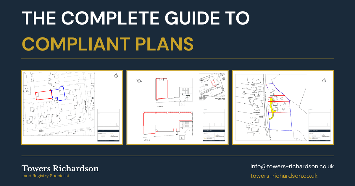
Step 2: Prepare the plan
A Land Registry compliant title plan must accompany the application. This must meet Practice Guide 40 requirements and show the property extent on the current Ordnance Survey map. For properties with old deed plans that do not match the modern OS map, a new plan reconciling the two may be needed.
Step 3: Complete form FR1
The application form requires details including the property address, the class of title being applied for, the applicant’s name and address, addresses for service, details of any overriding interests, and the fee.
Step 4: Complete form DL
This is a schedule listing every document being submitted with the application. Two copies of form DL must be included.
Step 5: Submit and pay the fee
The application, all documents, and the appropriate fee are submitted to HMLR. Applications can be lodged electronically through the portal (for business users) or by post.
Need a First Registration Plan?
Old deed plans that don’t match the OS map are the most common cause of first registration requisitions. We prepare compliant plans that reconcile your deeds with current mapping.
Get a Free Quote →5. What Plans Are Needed
The plan is one of the most critical elements of a first registration application — and the most frequent source of problems. HMLR needs to be able to identify the property on the Ordnance Survey map and create a new title plan.
Requirements for first registration plans:
- Must be based on or referable to the current Ordnance Survey map
- Must show the property extent clearly edged in red
- Must include a north point and stated scale
- Must show sufficient surrounding detail to locate the property on the OS map
- Must not contain disclaimers (“for identification only”, “do not scale”, etc.)
- Old deed plans should be submitted alongside the new compliant plan for reference
For first registrations, HMLR will accept old deed plans as indicative evidence of the property’s extent, but the application still needs a new plan that meets current PG40 standards. Where old deed plans show boundaries that differ from the modern OS map — which is extremely common — the new plan must reconcile the two, and the applicant may need to explain the discrepancies.
6. Dealing with Old Deed Plans
One of the biggest challenges in first registration is reconciling old deed plans with current reality. Properties that have been unregistered for decades often have hand-drawn plans from the early 20th century (or earlier) that bear little resemblance to the current OS map.
Common issues with old deed plans:
- Insufficient detail: Old plans may show the property in isolation without enough surrounding context to locate it on the modern map.
- Different boundaries: Physical boundaries may have shifted over decades — hedges grown, fences moved, buildings extended.
- Missing features: New roads, developments, or landscape changes mean the area looks entirely different from the old plan.
- No scale or north point: Many historic plans lack basic orientation and scale information.
- Ransom strips: A strip of unowned land may have appeared between the property and the highway, only becoming apparent when the modern plan is prepared.
A professional plan preparer can reconcile old deed boundaries with the current OS map by overlaying the two, identifying where boundaries align and where they differ, and producing a compliant plan that HMLR can work with. This is one of the areas where specialist expertise makes the biggest difference to the success of a first registration application.
7. Registration Fees
First registration fees are based on the property value and are calculated under Scale 1 of the Land Registration Fee Order 2024. Voluntary registrations receive a 25% discount.
| Property Value | Compulsory Fee | Voluntary Fee (25% discount) |
|---|---|---|
| £0 – £80,000 | £40 | £30 |
| £80,001 – £100,000 | £95 | £70 |
| £100,001 – £200,000 | £230 | £170 |
| £200,001 – £500,000 | £330 | £250 |
| £500,001 – £1,000,000 | £660 | £495 |
| Over £1,000,000 | £1,105 | £830 |
Fees are reduced by 50% when applications are submitted electronically through the HMLR portal or Business Gateway.
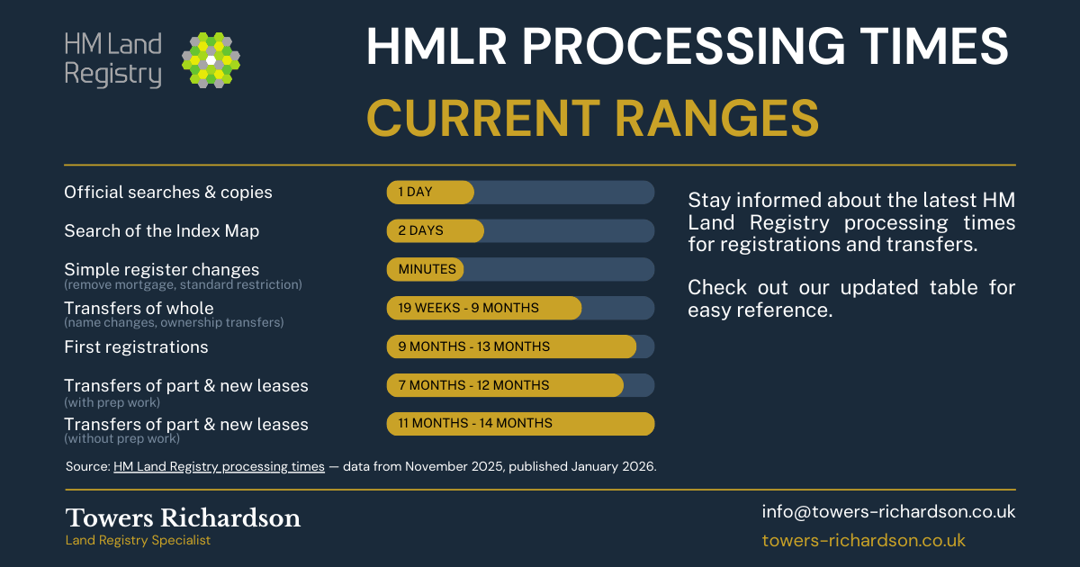
8. Current Processing Times
First registrations are among the slowest application types to process. Based on current HMLR data, you can expect:
- 50% of applications completed in approximately 9 months
- Most applications completed in approximately 13 months
- Applications with requisitions or complex title issues may take significantly longer
The good news is that your legal rights are protected from the moment HMLR receives the application — this is known as priority protection. Even if processing takes over a year, your ownership is secured from day one.
9. Common Issues and How to Avoid Them
- Get professional help with the plan: First registration plans are more complex than standard title plans because they must reconcile old deeds with modern mapping. A specialist can avoid the most common requisition triggers.
- Submit complete documentation: Use HMLR’s first registration checklist to ensure you have everything before submitting. Incomplete applications are a major cause of delay.
- Deal with missing deeds early: If original deeds are lost or destroyed, you will need a statutory declaration and should follow the guidance in Practice Guide 2.
- Check for boundary issues proactively: Have the new plan prepared well before you need it. This gives time to identify and resolve any discrepancies between the deed boundaries and the ground reality.
- Consider voluntary registration before selling: Registering before a sale avoids adding first registration delays and complexity to an already time-pressured transaction.
- Use a conveyancer experienced in first registration: Not all solicitors handle first registrations regularly. Seek one with specific experience — the requisition rate for first registrations is significantly higher than other application types.
10. Frequently Asked Questions
How do I know if my property is unregistered?
Search for it on the GOV.UK property search service. If no result appears, the property is likely unregistered. You can also apply for a search of the index map (form SIM) to confirm.
Do I have to register my unregistered property?
Only if a trigger event occurs (sale, gift, mortgage, etc.). If you simply continue to own the property without any dealings, registration is not compulsory — but voluntary registration is strongly recommended.
What happens if I miss the two-month deadline for compulsory registration?
The legal transfer becomes void — the legal estate reverts to the previous owner, leaving you with only an equitable interest. You should apply for registration as soon as possible and seek legal advice.
How long does first registration take?
Currently, around 9 months for 50% of applications and about 13 months for most. Applications with requisitions or complex title issues may take longer. Your rights are protected from the date HMLR receives the application.
What if my original deeds are lost?
You can still apply for first registration. You will need a statutory declaration and should follow the process set out in Practice Guide 2. Your solicitor can advise on the evidence needed to support the application.
Can I do a first registration myself?
Technically yes, but first registrations are significantly more complex than standard applications and have the highest requisition rates. HMLR itself recommends considering the benefits of using a conveyancer. We strongly recommend instructing a solicitor experienced in first registration work.
Need a First Registration Plan?
First registrations require plans that reconcile old deed boundaries with current Ordnance Survey mapping — one of the most common reasons these applications attract requisitions. At Towers Richardson, we have been preparing first registration plans since 1994 with a 100% HMLR acceptance rate.
We work with solicitors and property owners across England and Wales, turning complex old deed plans into clean, compliant plans that HMLR can work with.
Get in touch today:
📧 info@towers-richardson.co.uk
📞 01226 885040
💬 WhatsApp: 07543 434048
Or request a free quote online — we respond within 1 hour during business hours.